


No casualties in one of Indonesia’s biggest volcanic eruptions in 50 years. What lessons does it offer in disaster preparedness?
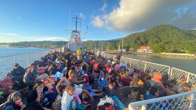
All 838 locals on tiny Ruang island evacuated before rescue teams arrived. Their disaster preparedness offers valuable lessons to others in volcanic areas, experts say.


This audio is generated by an AI tool.


JAKARTA: They live on a remote island in the Celebes Sea. The nearest search and rescue office is a six-hour boat ride away.
Against these odds, the 838 people who live in the shadow of Indonesia’s Mount Ruang managed to evacuate to safety just before the volcano rumbled to life in a series of massive eruptions last week.
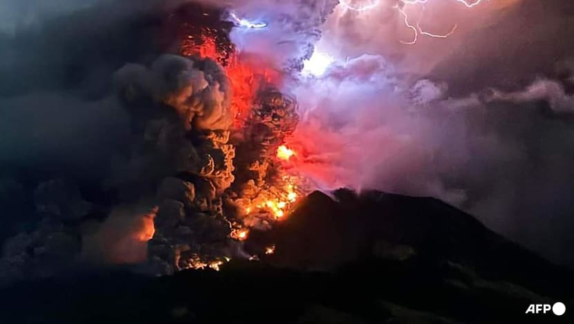
Scientists say last week’s eruptions were some of the biggest Indonesia has seen in the last 50 years, unleashing 200 million cubic meters of ash, hot rocks and lava from its chamber.
The intensity of Mt Ruang’s eruptions and the amount of material ejected were comparable to the 2010 eruptions of Mt Merapi, Indonesia’s most volatile volcano located 2,000km away in Java, which killed 353 people.
Yet, no lives were lost during Mt Ruang’s eruptions despite the relatively short window for the island’s inhabitants to evacuate. Ruang island is about 100km northeast of Manado city in North Sulawesi.
Although the government had recorded an increase in volcanic activities since Apr 10, locals were only told to evacuate at 2pm on Apr 16, mere hours before the first eruption at 7.19pm.
Rescue officials stationed in Sulawesi reached Ruang island the following day. By that time, the island was already deserted with all its residents evacuating on their own to the neighbouring island of Tagulandang, among other places.
“A speedy evacuation is critical in any disaster situation. And the fact that people on Ruang island did that on their own, with little intervention from authorities, shows how well their disaster preparedness is,” said Dr Eko Teguh Paripurno, a disaster mitigation expert from Yogyakarta’s National Development University (UPN).
They knew when to evacuate and where to go. This was the main reason why, despite the massive eruptions, there were no deaths reported.”
Mt Ruang’s eruptions have highlighted the importance of disaster preparedness among those living in remote areas with a high risk of natural disasters, Dr Eko said. Lessons include mapping out hazardous areas and communicating the risks clearly to inhabitants, having a fast and accurate early warning system, and ensuring people stay away from the exclusion zone.
The consequences of lax disaster preparedness can be dire, as seen during the Dec 3 eruption of Mt Marapi in West Sumatra, which killed 23 people. The mountain, a popular hiking spot, had been on a moderate alert level of two since 2011 and people were supposed to stay at least two kilometres away from the crater.
But hikers told local media that they were not briefed about the dangers by officials from the Marapi National Park when they obtained permission to enter the mountain, nor were there signposts warning people that they were too close to hazardous areas.

Indonesia has four volcano alert levels, ranging from normal to very high. The various levels have different exclusion zones that increase up to a six-kilometre radius around the crater. Mt Marapi is now at level three.
Before this month, Mt Ruang last erupted in 2002, according to the Smithsonian Institution’s Global Volcanism Programme. Since Apr 16, however, the volcano has erupted eight times – on occasion, so powerfully as to spew a towering plume of smoke more than three kilometres high.
Ashes from the volcano later spread to the main islands of Sulawesi and Borneo, disrupting air travel and forcing the closure of some airports including Manado’s Sam Ratulangi Airport, which was shut for five days.
Mt Ruang’s volcanic activities have since receded but as of Thursday (Apr 25), people were still barred from setting foot on the 19 sqkm island.
STRINGENT POLICIES ARE KEY
Straddling the Pacific Ring of Fire, Indonesia is home to 127 volcanoes, 76 of which are considered very active.
Several of these volcanoes are completely surrounded by the sea.
“There are many volcanic islands which share a similar situation as Mt Ruang,” said Professor Irwan Meilano, dean of the faculty of earth sciences and technology at the Bandung Institute of Technology (ITB).
Some of these volcanic islands are now uninhabited – like Krakatoa, whose cataclysmic eruption in 1883 triggered a tsunami that killed more than 36,000 people.
But there are those which are occupied by many inhabitants like the 76 sqkm island of Ternate, where more than 200,000 people live in the shadow of the volatile Mt Gamalama. The 1,715m-tall mountain last erupted in 2022.
“For islands like this, it is important to properly map out where the hazardous areas are,” said Prof Irwan, adding that these risks must be communicated properly to all inhabitants of such islands. This, he continued, should apply to both sparsely and densely populated volcanic regions.
“The key is stringent spatial planning policy. There are areas which are not fit for human settlement. Meanwhile, areas which can be settled must have clear evacuation routes,” he said.

The majority of Ternate’s inhabitants live on the southeastern side of the island, away from the lava flow which has historically affected the northwestern slopes of Mt Gamalama.
Ruang island, however, is about a-fourth the size of Ternate. Based on previous eruptions, scientists consider the entire island vulnerable to lava flows and fast-moving clouds of gas and volcanic matter in the event of an eruption. Historically, Mt Ruang’s eruptions have also been many times more powerful than Mt Gamalama’s.
The only escape route is by boat to the larger nearby Tagulandang island, which is about 1km away.
“Because the only evacuation routes are by sea, timing is key,” said Dr Eko of UPN Yogyakarta. “Which is why disaster preparedness training as well as a fast and accurate early warning system are so important.”
BETTER MONITORING NEEDED
Predicting Mt Ruang’s next eruption will be a challenge.
Because of its remoteness, the 725m-tall volcano is not well recorded or studied. There is only one observation station on Tagulandang which monitors the volcano’s seismic activity remotely based on a series of instruments installed at the slopes of Mt Ruang.
In contrast, Indonesia’s most volatile volcano, Mt Merapi in Java (not to be confused with Mt Marapi in West Sumatra), has three observation outposts.
This allows scientists to measure more accurately how much the volcano is deforming, a sign that pressure is building inside the volcano, or spot any other irregularities.
They can then better predict when an eruption will happen – possibly days or even weeks in advance – providing officials more time to evacuate residents.
In contrast, officials only had hours to warn Ruang island residents of an imminent eruption.
“Mt Ruang’s activities increased quite suddenly and escalated quickly,” Mdm Heruningtyas Desi Purnamasari, a volcano observation team leader with the Indonesian Volcanology and Geological Disaster Mitigation Centre (PVMBG), said at a press conference on Apr 18.
The situation deteriorated so rapidly, the PVMBG had to raise Mt Ruang’s alert level twice on the same day on Apr 16, and ordered residents to stay at least four kilometres away from the crater.
After the second eruption in the early hours of Apr 17, Mt Ruang was on the maximum alert level of four and the exclusion zone was raised to six kilometres around the volcano, meaning some residents on neighbouring Tagulandang also had to evacuate.
As of Thursday, more than 14,000 people were evacuated and seeking shelter in the safer parts of Tagulandang as well as Sulawesi.
Given Mt Ruang’s history of triggering a deadly tsunami, scientists say it should be better monitored.
“During an eruption in 1871, there were witnesses who said that there was a tsunami whose height reached five metres. But there are those who said (the tsunami) could be up to 25m (by the time it reached) other islands,” said Dr Mirzam Abdurrachman, a volcanologist from Bandung Institute of Technology.
At least 400 people were killed in the 1871 tsunami, caused when sections of Mt Ruang collapsed and created massive waves that travelled for tens of kilometres.
There were similar fears last week, prompting officials to issue a tsunami warning as a precaution. But the warning was withdrawn on Monday (Apr 22), after PVMBG officials determined the volcano would remain relatively intact in spite of the ongoing eruptions.
Scientists say if there had been a tsunami last week, there would have been a higher chance of deaths.
The last time a volcano-triggered tsunami occurred in Indonesia was in 2018. More than 400 people in coastal areas surrounding Krakatoa were killed.
‘COMPLACENCY IS THE NUMBER ONE KILLER’
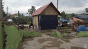
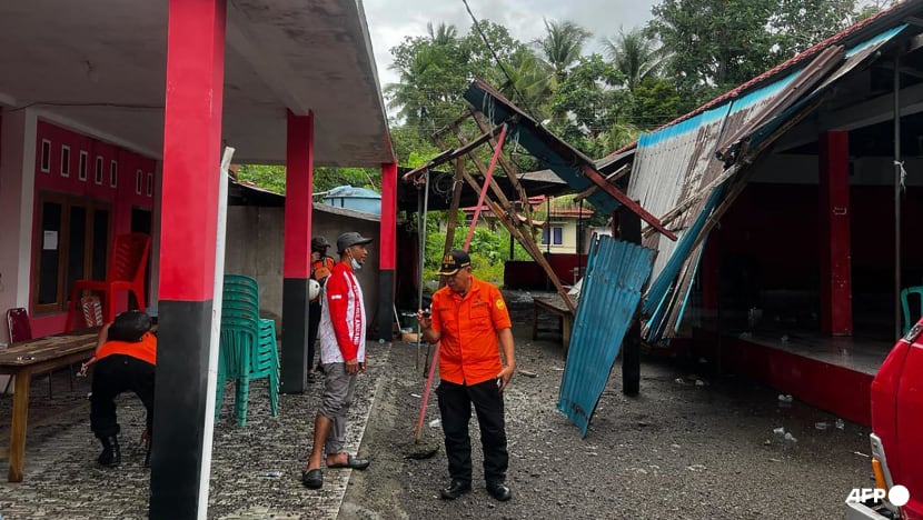
The National Disaster Mitigation Agency (BNPB) said last week’s eruption damaged more than 3,000 homes as well as several churches and schools in both Ruang and Tagulandang.
Aerial photographs taken by rescuers and local journalists showed nearly all structures in the affected areas covered in volcanic ash. Some were charred by the extreme heat, while others were damaged by hot lava rocks falling to the ground.
On Apr 22, the PVMBG lowered the alert level of Mt Ruang to three but still declared the volcanic island as well as parts of Tagulandang within a four-kilometre radius from the crater off limits. The centre warned that Mt Ruang continued to show activity and has not returned to normal.
The warning has not deterred a few Ruang residents from secretly returning to inspect their damaged homes and retrieve some of their belongings.
“I came to pick up my generator, my washing machine and a few other tools we will use at our refugee camp,” a Ruang Island resident named Mr Dikson told Indonesian news portal Berita Satu on Tuesday (Apr 23).
Mr Lilik Kurniawan, BNPB deputy for logistics and equipment, said officials will conduct patrols and erect warning signs to keep residents from entering the island.
“We want to remind people that the island is still considered as a high risk area,” he said in a statement on Thursday.
Mr Lilik also promised the authorities would meet the evacuees’ need for shelter, food and clothes.
Dr Eko, the disaster mitigation expert, said it is important to ensure that the locals stay away from the exclusion zone, which can be in place for years as is the case with Marapi.
“In many disaster situations that I have observed, the number one killer is complacency, the thinking (that) ‘I’ll just ignore the warnings for a little while, it will be alright’. Especially now that volcanic activities have receded and people are getting tired of living in refugee camps,” he said.
“The situation can deteriorate again. The volcano can still erupt. People need to stay vigilant.”


